Cusco, Peru
3600 m
January 7th, 2001
This has been a frustrating day! Since reaching Cusco I have been trying to find information about trekking the famous Inca Trail, especially if I can get a solo permit. The rumours about the Inca Trail that I heard in Lima seem to be true. The rules changed as of Jan 1, this year and henceforth they will not allow anyone to trek individually. But trudging from  tourist office to the government office to assorted offices that have no names, asking for information I get the sense that nobody really knows whether or not it is to be enforced yet. More to the point, they don’t care that much. So there is hope yet. I’ve been getting the “manana” response and so manana it will be.
The very thought of being herded in a tour group or hiring a guide makes me break out in hives! But all is not lost yet. Gareth, a young man from Wales who is staying at the same place as I is keen to trek it as well. He hasn’t any equipment and would prefer not to hike solo. I offered to share my stove and other gear but mine is a one-man tent so we’ll need to rent a two-person tent. But all that is secondary. First we need that permit. Maybe we can get a permit since we are now a group of two? Who knows? It is worth a try. I hate the thought of being here and not hiking this trail.
Cusco
January 8th 2001
For some bizarre reason I woke up early and couldn’t get back to sleep. Out on the balcony, I was watching the rain drizzle down on Cusco rooftops and the distant peaks playing peek-a-boo with the mist. I was mulling over options if I could not get a solo or group-of-two permit. I have been poring over the map. I could hike the trail from Mollepata that goes past Salcantay (at 6300m) with its glacier-laden surroundings. It would meet up with the railroad and I could hop onto the train at the Km 88 station. From Aguas Calientes, a trail leads up to Machu Picchu. Not the best, but at least I’ll get to hike some of the trail and see Machu Picchu. I’ll have to see if Gareth is still interested.

Sometime in the late afternoon
Plaza de Armas, Cusco
I can’t believe it! Just earlier today I was hatching alternate plots and now it is all set. Perhaps it has something to do with the good karma that that sadhu in Kathmandu had told me about. He had popped up in my mind for no reason last night. Who knows? Strange are the ways of the world.
First thing in the morning Gareth and I walked to the Info Peru office in Plaza de Armas. With my best pleading face on, I tried to explain to the sole occupant of the office, how much this means to me. That, combined with Gareth’s hitherto unknown, latent histrionic talents got us a “maybe” sort of response. We were told to go to the INC – the Institute of National Culture, a couple of blocks away. With a new spring in our step we scuttled off. We were ushered into a cell-like office and pleaded our case. And voila! The answer was yes. The fee had gone up from $17 per person to $ 50 as of Jan 1st but no, we did not have to go as a tour group nor need to hire a guide. We got our permits, one for each of us for four days beginning tomorrow. In the giddy daze of delight I asked if we could pay for a longer permit of seven days.
“No” said the man, his smile saying a moment ago all I wanted was a permit and now I want even more?
“Okay, okay”, I said, “No hay problema” and we walked out sporting huge grins. Well, Gareth walked and I did little jigs every few steps. Those tell-tale little shivers of excitement kept going up my spine every so often.

10 –ish pm
Alberge Municipal, Cusco
The rest of the day was spent getting bus tickets to Km 82 where we begin the hike, renting a sleeping bag for Gareth and renting a tent – the one with least number of tears and zippers with some semblance of functionality. Lightweight is not a concept that relates to rented tents but Gareth has offered to carry it while I carry the stove and fuel as well as the bulk of the food. A more or less fair division of labour, methinks.
It was late by the time we finished dinner with a couple of other travelers I had met and packed our packs. But there they sit, at the foot of the bunks, ready to be strapped on. I intended to fire the stove but did not get to it. Maybe tomorrow morning before we head out.
Campsite at Wayllabamba
3000 m
January 9th
After rushing to get to the bus at 6:30 am, we spent the next hour or so in the bus as it meandered through Cusco picking up other passengers. All were people in a large tour group. Being picked up from your doorstep must be one of the perks of being on a tour group! Apparently individual trekkers such as us do not warrant this privilege.
The road soon left Cusco and ran through the countryside past small fincas and farmhouses. The green canopy-covered hillsides lay wreathed in the morning mist. Small towns lay like beads on the mud-bogged road and at the stops, vendors braved the drizzle to hold up  souvenirs for sale at the windows. We stopped briefly for breakfast at Urubamba and trundled on again, more or less next to the train tracks and the river. Villages are few and far between along this stretch. I wave at some of the children by the side of the road but they do not wave back. Km 82 came sooner than I expected and by 11 am we were at the last stop, the trailhead. The others on the bus were herded by their guide into a group and were being drilled about the day’s trek.
Gareth and I registered at the trailhead and had our passes checked before setting off. It was overcast and cool as we walked, keeping the river to our left. The path was easy to find as it  meandered gently up and down and soon we reached ruins of Llaqtapata or sometimes called Patallaqta. The name means “Town in the Heights” although at 2650 m, this did not seem quite so apt. There were many other towns at higher altitudes. But the sight itself was awe-inspiring. The geometric semicircular construction showed terraces set neatly against the mountainside, exploiting the natural contours. The design and construction was impressive and it must have been a formidable stronghold. The trail from the west (Km 88) joins up here and we kept walking.
The Inca Trail is most famously known for the ruins of Machu Picchu but in reality, there are ruins all along the way. Sometimes there are ruins of towns and sometimes they are rest areas built a day’s march apart to accommodate travelers, merchants, pilgrims on their way to Machu Picchu. Sometimes the ruins are old-time watchtowers poised at critical places to keep watch over this trail. Oftentimes they are closer than a day’s march. Each building or even the area adheres to a rigid geometric symmetry – sometimes built in a semicircular fashion, sometimes showing a trapezoidal symmetry or sometimes triangular. Each is built in tiers across the mountainside with walls made of closely placed rocks and sculpted terraces. Each has names, usually quaint names that echo the physical attributes of the ruins. 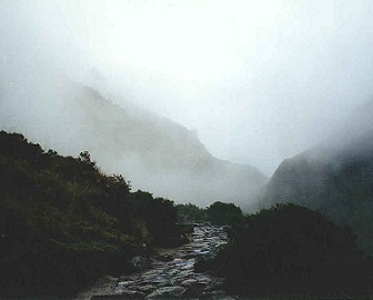 A couple more hours on the trail and we came to Wayllabamba, the site of the first night’s camp. The name means a grassland or the “Green Place” and it could not have been more aptly named. The large group we shared the bus with were not the only ones; there were others as well. We steered clear of them and climbed up a bit more. We camped high above the group sites and from our site we could see the mini village formed by the tour groups. How glad was I not be a part of that melee! I mentally thanked the accommodating man at INC again for granting us our permits.
Campsite below Runkuraqay
3680 m
January 10th
7:30 pm
Gareth had a confession to make last night. He confessed to being cheerful morning person.
“What?” I asked. “And you are telling me this now?”
I had to impress on him that I most definitely was not a morning person. More importantly, I had to make him aware of the dire consequences of hiking together, especially sharing a tent if he could not contain his exuberant good mood at the crack of dawn. Apparently the message was received loud and clear. Despite setting the alarm for 5 am, neither of us got up then.
 It had started raining when we pitched the tent and had rained steadily through the night. The rented tent, in the manner of all rented tents, had leaked. But it was not too bad. At least not yet, that annoying part of my mind reminded. Our camp was in a small field owned by a local farmer. It was terraced on the hillside, close to the trail and one of the highlights was the sight of Mt. Veronica, seen in the “V” between the two ridges to the forefront. The rain tapered to a misty drizzle as we sat over coffee and breakfast. Mt. Veronica appeared magically as the clouds cleared, its snow-covered slopes seeming to float in midair. We nodded to the long streams of people from the group tours as they streamed past; they must have struck camp a while ago. By the time we finished breakfast, rolled up the wet tent, more-than-a-little damp sleeping bags and packed, everyone else was long gone. But it was only 8:30 am.
The trail today is supposed to be the hardest day of this trek. It is the long climb toward the Warmiwanusqa pass. At 4200m, it is not particularly high, but it is the highest point of this trek. I was a little worried. I know given time to acclimate, even 6000 m would not be a problem. I have climbed to that level and higher before. But we hadn’t the luxury of time on this trek; the four day pass meant we had to do the trek at a pace determined by the powers-that-be. The name means Dead Woman’s Pass – hardly something to put my mind at ease. Gareth was even more anxious; he had never been remotely close to this altitude and as he confessed, is not really a trekker.
“So”, I asked him, “How many more deep dark secrets are you keeping to yourself? You might as well confess all now”.
He pleaded none. I had to urge him to keep drinking water.
“Drink until your guts feel like bursting” I told him “and then drink some more. It is the only thing you can do, bar medication, to counteract altitude sickness.”
His expression said I was missing more than a few marbles but he did as he was told.
The long climb toward the pass was hard and the fact that the INC maps (crude at best) and the one in the Lonely Planet guide did not match, did not help. Oh, how I wished I had a  topo! A stop for a hot lunch at one of the sites below the pass was welcome but the brief interval did not help me get acclimated. I could feel the beginnings of a pounding headache. False summits kept appearing as they always do and the pass, the dreaded pass, that should have come soon, didn’t. Well, it did, at around 3:15 pm. We had taken a long lunch break but despite that, the going was slow. Towards the final climb to the pass, I had to stop every hundred steps or so. I had to pause, let my breathing return to normal and start plodding again.
“How strange” I thought. “I have been higher than this before and did not have to labour nearly as much”.
“Ah, but that was in the Solu Khumbu, in Nepal”, my other mind answered, “Where you did not have to toe the line of the prescribed days and dates”.
Strangely though, except for becoming really slow, I did not feel any other effects of the altitude. Gareth had kept plodding on. He does not trek routinely and despite never having been at this altitude, was gamely putting one foot in front of the other. I mentally applauded his cheerful attitude but lacked the strength and breath to put it in words.
 The top of the pass spelt relief for us both. It had been raining almost constantly all along the way and with the mist and clouds rolling in, there wasn’t much of a view. All along the trail we had seen vegetation and now, through a gap in the mist I saw a herd of llamas grazing. The herd was too far to get a good photograph but near enough to incite awe at these strange creatures in their equally strange habitat.
After the pass came the steep downhill. Not a problem for either of us, we made good time. Parts of the trail had large bushes of purple-white flowers edging the trail. Combined with the stone-paved trail, the stone steps, it almost seemed like a well-tended nature trail in a well-maintained city park somewhere. Waterfalls cascaded down distant slopes on the opposite wall of the canyon. It was pretty. And so here we are at the campsite, just below the next climb up to the second pass tomorrow. Arriving around half past four this afternoon, we looked at the sites. Denuded of any grass, the dirt-laden campsites have long since become muddy bogs. The idea of pitching a tent in the ankle deep mud was far from enticing. While I put my pack down and looked to see if there were any remotely dry spots, Gareth had wandered into one of the permanent buildings and wandered out with a man. Short, stocky with sincere eyes, the man greeted us pleasantly and introduced himself. Manuel is a policeman who stays at this guard post for a few months each year. He checks the permits, sees to it that no rules are broken at this site, he says. All the driest sites are taken tonight he says. He points to a small sheltered passageway between two buildings and offered to let us pitch our tent there.
Oh to be out of the rain that is fast turning to needle-sharp ice pellets! We pitched our tent and left off the rainfly and set up the stove in this space. Dinner over, Gareth, Manuel and I chatted over cups of mate de coca. The ends of the thatched roof above dripped constantly and the view of waterfalls on the slope opposite could be seen through a curtain of water. The dull drum of the rain made for a pleasant background as we chatted.
At 3600 m, it is significantly colder here than it was last night. My watch says 9 C and it also says it is only 9:00 pm. Early though it might be but I am ready for bed. Gareth has been curled up in his bag for a good half hour already.
Refugio at Intipata
January 11th
We started out around 8:30 am again but the others from the tour groups must have started late; we passed and by-passed each other all along the trail. First came the steep uphill  climb to the ruins of Runkuraqay. The name means the round house or rather, the oval building and it is just as the name describes. It is positioned superbly at the edge of a plateau so it commands a view of the trail coming into and leaving the site. Wonderfully preserved, it still performs as a spectacular watchtower. Built of large rocks in the typical Inca style, it overlooks the steep canyon up which we had climbed. This was a guardhouse, designed to keep watch on the Inca trail to Machu Picchu.
Past a couple of lakes, now stagnated, and we were at the top of the pass at 3998 m. Then  came the long downhill and at the end of it, the ruins of Sayamarca. The name means “Raised over a High Place” and just as the names says, it is built on the edge of a ridge, overlooking the densely forested mountains and canyons. This was supposed to be a resthouse – an ancient motel for travelers on the road to Machu Picchu. From there the trail climbed gently toward the campsite – our third and last night.
In walking among and past the tour group, catching up on rest stops we had started chatting with some of them. Along with the four British guys – Ash, Ravi, Richard and the fourth whose name I never learned, I also met Sven from Germany. There is also the couple from Australia who are on their honeymoon. I can’t remember their names now but given how she felt about the constant cold and rain, I doubt their next trip will be anywhere but on a warm beach! The folks on the tour have it a tad easier since they only carry their small daypacks while a herd of donkeys carry their gear. But talk of the constant cold, rain, sleet and sporadic snow at the top of the pass seems to create a bond. A shared bond of self-inflicted misery, we say as we laugh at ourselves.
After the third pass, the trail was mostly level, climbing up and down gently. Hugging the sides of the mountain, this well constructed paved trail is an engineering marvel! On one side is sheer rock, its face covered with lichen and moss, in colours of green, yellow, orange and brown. Sometimes there are small shrubs and bushes, their roots finding ways to anchor into small cracks and fissures in the rockface. I had smelt blueberries earlier and soon saw dwarf bushes. Not yet ripe, they were too green to eat.
The construction of this trail makes my mind boggle. At places they have sheer drops of two thousand meters or more. Following the natural contours of the mountains, this trail is not only carved out, but laid out and paved with huge blocks of stone, the surface of each huge step, perfectly levelled. Some of the paving stones probably had to be ferried from a fair distance away. And along its path sometimes there are tunnels. In some places perhaps a hole already existed and was enlarged into a tunnel large enough for a man and a loaded donkey. In some places though it was intentionally carved into the cliffside. How did they manage that at a time when modern machinery was non-existent? How long did this endeavor take? How many perished in the process? Those were questions that peppered my mind as we walked.
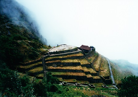 On and on we walked across places where the views should have been stupendous. But we were not so blessed. Clouds, fog and mist surrounded us almost all the way. Having crossed the pass we looked down to see yet another ruin, Phuyupatamarqa. This name means “Town Above the Clouds”. Bigger and more grandly built than Sayamarca, this one stretched across the mountainside, triangular in shape from our vantage point. Some of the terraces have sharply constructed edges. Precisely engineered and constructed, the angles remain sharp even after all the years that nature has had to round them off. Tiered walls slope down, each connected to the previous by a narrow channel. Water channels, presumably, there is water there still, thanks to the more or less non-stop downpour these last three days. We filled up our water bottles from the topmost one and continued downhill.
From about 3700 m, the trail led steeply downhill over a series of steps carved out of rock. Most of these steps date back to the Inca times, their age showing in the dips and rounded-off parts. The dimensions of the steps puzzled me though. From all I had read and knew, the Incas were not a tall race. Why then, were these steps gigantic? For the vertically challenged such as I, it was no easy feat to step from one to another! Certainly not with a loaded pack and not with any semblance of ease.
The next ruin along the way was Winaywayna. By this time the terraced structure was  becoming familiar but nonetheless, still amazing. The name meaning “Forever Young”, makes me wonder who named it. After whom was it named and why? I weave all sorts of tales in my head as we walk past. Winnaywayna is built on the top third of a hill, with the concave semicircular terraces hugging the contours of the hill. Steep stone steps lead down from the top to the bottom. Far below I can see the Australian couple, she in the pink poncho is lying flat on the ground. We wave to each other.
Down, down, down we went, nearing the last campsite at Intipata. The rain has been coming down with a vengeance. Rumour had it that there was a refugio at this site. With all our gear, sleeping bag and just about everything we had still wet, I was beginning to fantasize about staying under a roof. To forget about pitching the tent and sleep in a warm, dry bed. The operative word being “dry”. Gareth had the same fantasy. Apparently so did everyone else who had been on the trail.
I arrived at the refugio looking more like a drowned rat than anything else. I had company as we looked at each other, all the ones from the trail. Dinner on the patio while listening to the continuing rain drum on the roof and watching the snow on the distant peaks turn a peachy orange in the sunset was lovely. Just the prospect of not having to battle with a wet tent was enough to make me happy. A hot bath would have been heavenly but there is no such prospect in sight. No matter, I think. Tomorrow, there are the hot springs at Aguas Calientes, we remind ourselves.
Machu Picchu
January 12th
10:15 am
I am sitting at the outdoor table of a café at the ruins of Machu Picchu. A tinny speaker is squawking out a Beatles song, played on Peruvian pipes. The couple from Argentina are here as well. We had not exchanged names before but do so now. This is a first trip to Peru for Marianela and Jose as well. Sharing a last bar of chocolate, we sit and gaze at this that we started on the trail to see. Gareth has gone off to look for some others. They want to climb up to the peak that forms such a dramatic background to this site. A pair of llamas graze undisturbed nearby. Far above there is a hawk circling in the sky. After all the days of rain, today the sky appears cloudless.


We started out before dawn for a short stretch ending in Machu Picchu. Around one corner and suddenly before our eyes were the ruins. Machu Picchu. The name conjures up the grandeur that was the Inca Empire and the ruins here justify it. Most of the top of this mountain has been sculpted into terraces and sectioned off neatly into quadrants, separated by walls. Each wall is made of individual stones stacked together with such finesse, that are no chink or gaps in between, even without the use of cement. The walls of the houses rear up in triangular symmetry, the roofs long since decayed. They must have been made of wood or thatch and so did not survive as the stone walls do. There is such a sense of beauty and aesthetic appeal in this design! Each level is staggered – such a symphony of multi-leveled architecture is Machu Picchu. There are walkways between buildings and between the different quadrants, all paved with the same stones and in the same manner that we have seen all along the trail. In between are terraces, green with emerald grass.
All around this site in 360 degrees are mountains. Sharp steep edges and profiles that look sculpted. Almost as if someone took a knife and carved them in helical forms. There are clouds, hanging like half curtains on all sides. But Machu Picchu itself sits bathed in a circle of sunshine. There is a quiet dignity to it. There is a sense of harmony and beauty that not even the throngs of loud tourists that the tour buses have just disgorged can take away. There is magic to this place.


Aguas Calientes, Peru
January 13th
The steep mountain atop which lies Machu Picchu, boasts a trail down to the bottom, but there is a paved road that hairpins its way down and on this road plies dozens of tour buses. We bought ourselves tickets for the way down. I noticed that most others gave us a wide berth – no doubt we smelled ripe from our days on the trail.
Arriving in the tiny hamlet of Aguas Calientes and finding a place to stay was simple. What was by far more wonderful was gorging ourselves on trucha a la macho, the local specialty, so said the locals. And gorge, we did. Even better was soaking in the hot springs. Rock-walled pools filled to overflowing with steaming sulphurous gray-green water. Ah, that was truly heavenly. All the aches, pains and cold that had seemingly seeped into my bones melted away. Bliss, pure bliss! We stayed in until our fingers turned into prunes and the baths closed and then dragged ourselves back to the inn. Barely able to keep our eyes open, we stumbled back to fell into dead sleep. We had to wake early to catch the Touristica Economica, the tourist train to Ollanta and then the bus from Ollanta to Cusco the next day.
Cusco
January 14th
There is a cheap local train and bus to Cusco, but apparently as tourists, we were not allowed on it. Instead, we had to purchase tickets on the Touristica Economica and then on the similar, if not similarly named, bus into Cusco. And so, we left at 6 am. But little did we know that this last bit would be the final cap to our Inca Trail adventure!
The train arrived and we got on with the rest of the tourists, all herded into the tourist coach, carefully segregated from the locals. Free cups of coffee was an unexpected boon but the real surprise came when the train broke down and apparently the combined efforts of  the driver, engineer and assorted local help failed to get it moving.
In typical fashion, some time was spent in discussing the problem with conflicting opinions and information on availability of the next train flying back and forth. An estimate of a minimum of four hours, sagely agreed to by all the experts, decided the matter for us and most of the others. Hefting our packs, we started walking along the railroad tracks toward Km 82. There was a bus from Km 82 to Cusco – hopefully we should be able to get on it.
Some six kilometers and a couple of hours later we reached the trailhead from which we had started only five days ago. It seemed so much longer though! Having to walk the extra six kilometers when we had not intended to, should have been irksome but strangely wasn’t.
And by the time we reached Km 82, it seemed luck was on our side. A bus was loading up to leave. Gareth, I, Marianela and Jose and a few of the others loaded our backpacks and got on. Some sitting, some standing, we jolted off to Cusco and reached around noon.
